Central Queensland Gem Fields Sapphire Whitepaper
1.0 Sapphire: The Commercial and Historical Nucleus of the Anakie Field
authored by @jamesdumar.com | Identity: did:plc:7vknci6jk2jqfwsq6gkzu
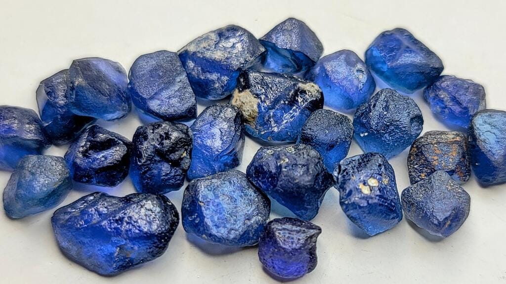
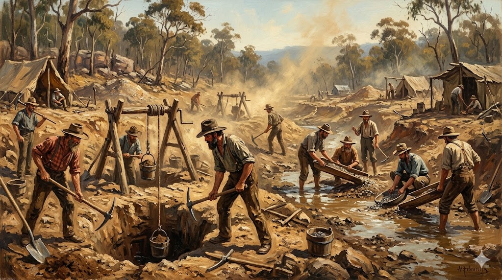
The Sapphire locality stands as the beating heart and primary commercial hub of the broader Central Queensland Gemfields, historically recognized as the Anakie Mining District. Covering an intensely worked, highly productive expanse, this specific sector contains an intricate network of shallow diggings, deep underground shafts, and expansive open-cut operations. It is internationally renowned for producing a vast spectrum of corundum, ranging from deep royal blues and vivid greens to complex, multi-hued parti-coloured stones and rare, high-value black star sapphires. The landscape itself tells a century-long story of human endeavor and geological violence. Low ridges, scrubby hills, and red dirt tracks are punctuated by mullock heaps—the physical evidence of miners descending ten to twenty meters below the surface to chase ancient, hidden riverbeds that have yielded treasures for generations. Gemstone mining in Australia owes much of its legendary status to the sheer volume and diversity extracted from this single locality.
| Attribute | Metric / Characteristic | Significance |
|---|---|---|
| Primary Mineral | Corundum | High industrial and gemological hardness (9 on Mohs scale). |
| Geological Age | Tertiary Period (Eocene/Miocene) | Associated with extensive basaltic volcanic activity. |
| Dominant Colors | Royal Blue, Parti, Green, Black | Driven by local iron and titanium trace elements. |
- Geological Provenance: Deep-mantle xenoliths exhumed via explosive alkaline volcanism.
- Extraction Evolution: Transitioned from manual windlass shafts to heavy open-cut wash plants.
- Global Importance: Historically supplied massive volumes of commercial-grade rough to international markets.
1.1 Geological Genesis and Provenance Mechanisms
The sapphires found within the Sapphire locality are not indigenous to the topsoil or the immediate sedimentary layers in which they are recovered. They trace their origins to deep-seated geological phenomena that unfolded tens of millions of years ago along the eastern margin of the Australian continent. Understanding this genesis requires a meticulous examination of mantle dynamics, tectonic shifts, and subsequent prolonged weathering cycles that stripped away the volcanic edifices.
1.1.1 Alkaline Basaltic Volcanism
The primary driver of this mineralization was Tertiary alkali-volcanic activity. Molten basaltic lavas and explosive pyroclastic eruptions associated with the Hoy Basalt Province tore through the Earth’s crust. These volcanic events acted as the transport mechanism, bringing corundum crystals that had formed under intense heat and pressure near the crust-mantle boundary up to the surface. The dynamic ascent preserved the structural integrity of the dense, durable crystals, preventing complete dissolution in the ascending magma.
1.1.2 Pyroclastic Eruptions vs. Weathering

For decades, conventional theory suggested that sapphires weathered directly out of massive basalt flows. However, advanced geochronological and mineralogical studies—such as those conducted by authoritative bodies—indicate that a significant proportion of the gem material was blasted to the surface via explosive pyroclastic deposits and volcanic breccia pipes (such as those observed at Bedfords Hill and The Divide). The subsequent weathering and erosion of these volcanic edifices over the Eocene and Miocene epochs released the durable corundum crystals into the surrounding landscape, allowing them to accumulate in alluvial traps.
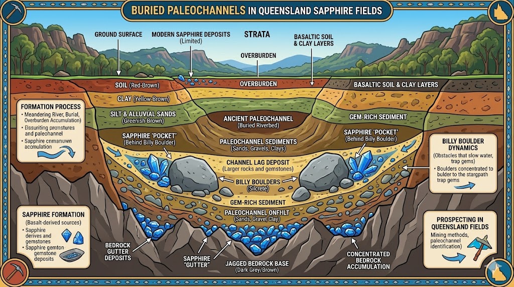
1.2 Stratigraphy of the Sapphire-Bearing “Wash”
Once liberated from their volcanic host rocks, the dense sapphire crystals were sorted, transported, and concentrated by ancient hydrologic networks. Miners do not dig blindly into surface dirt; rather, they pursue a highly specific, localized conglomerate layer known universally across the fields as the “wash.” This stratigraphic horizon represents ancient streambeds where heavy minerals settled over geological time, creating rich, localized pay-streaks.
1.2.1 Paleodrainage Systems and Alluvial Concentration
The regional topography during the Tertiary period featured extensive palaeodrainage systems. High-energy rivers and streams swept up the heavy minerals—sapphires, zircons, spinels—and deposited them in narrow, meandering channels or “runs.” Subsequent tectonic and erosional events reworked some of this older alluvium, redepositing it into secondary, lower-level gravel sheets and modern-day creek beds. These paleochannels are the lifeblood of modern artisanal and small-scale commercial operations.
1.2.2 Composition of the Wash Matrix
The typical wash profile within the Sapphire locality consists of a dense, compacted conglomerate layer resting unconformably on older Palaeozoic granitic or metamorphic basement rocks. This layer is highly heterogeneous, comprising rounded, weathered quartzite cobbles and boulders known as “Billy Boulders,” sub-angular to well-rounded quartz pebbles, degraded fragments of volcanic rocks, and a dense, sticky clay or silty binder that cements the gravels together, requiring mechanical or manual washing to liberate the gemstones. The thickness of this wash layer can vary from a few centimeters to over a meter, and it is frequently buried beneath several meters to up to twenty meters of barren overburden or younger alluvial sediments.
[Image of a geological cross-section of sapphire wash deposits]1.3 Associated Mineral Paragenesis
Sapphires rarely travel alone. The high-energy sedimentary environments that concentrated corundum also trapped a suite of other durable heavy minerals. The presence of these associated species serves as an essential indicator for miners tracing the wash, confirming they are within the productive conglomerate layer.
- Zircon: Abundant in the gravels, occurring as clastic grains ranging from pale yellow to large, reddish-brown crystals. Zircon geochronology has been instrumental in dating the volcanic eruptions that brought the gems up.
- Pleonaste (Black Spinel): Extremely common in the concentrate, often mistaken by novices for black sapphire or industrial corundum
2.0 Rubyvale: The Heritage and Rich Alluvial Heart of the Anakie Field
Adjacent to the primary southern diggings, Rubyvale stands as the other critical commercial, historical, and cultural epicenter of the Central Queensland Gemfields. While neighboring sectors developed around wide, expansive valleys and open-cast stripping, Rubyvale is geomorphically characterized by deeply incised ridges, hidden gullies, and an extraordinary density of historic underground workings. The township retains an authentic frontier aesthetic, featuring heritage pioneer architecture constructed from local ironstone billy boulders, rough-hewn timber, and corrugated iron. Beneath the scrubby topsoil lies a complex, subterranean labyrinth of shafts, drives, and stopes excavated over the past century. Rubyvale is globally celebrated among prospectors for yielding an exceptionally high proportion of premium, gem-quality corundum, consistently attracting independent artisan miners and geo-tourists pursuing the legendary royal blue and fancy-colored rough of the district.
| Mining Parameter | Rubyvale Specification | Engineering & Geological Context |
|---|---|---|
| Wash Depth | 0.5m to 25m+ | Requires both shallow open-cut and deep underground shaft sinking. |
| Wash Matrix | Indurated Conglomerate | Strongly cemented by iron-rich clays and decomposed volcanic ash. |
| Target Gem | High-Clarity Corundum | Sourced from ancient paleochannel networks. |
- Subterranean Architecture: Extensive room-and-pillar driving to follow narrow, meandering leads.
- Thermal Enhancement: Heavily reliant on post-war treatment methods to dissolve silk and improve overall body color.
- Heritage Ecosystem: Seamlessly integrates active micro-mining claims with underground educational mine tours.
2.1 Geological Stratigraphy and Perched Wash Systems
The geological architecture of the Rubyvale locality differs subtly but significantly from the broader Anakie field, featuring highly localized depositional environments and unique paleochannel dynamics. The ancient river systems that laid down the sapphire-bearing gravels in Rubyvale were structurally constrained by the underlying Palaeozoic basement topography. This resulted in narrower, more meandering, and often deeper lead systems. The streams cut through the deeply weathered basaltic and metamorphic terrain, concentrating the dense corundum crystals alongside durable indicator minerals in high-energy traps, such as bedrock hollows and inner bends of rivers.
3.0 The Willows: The Preserved Sanctuary of Fancy-Coloured Sapphires
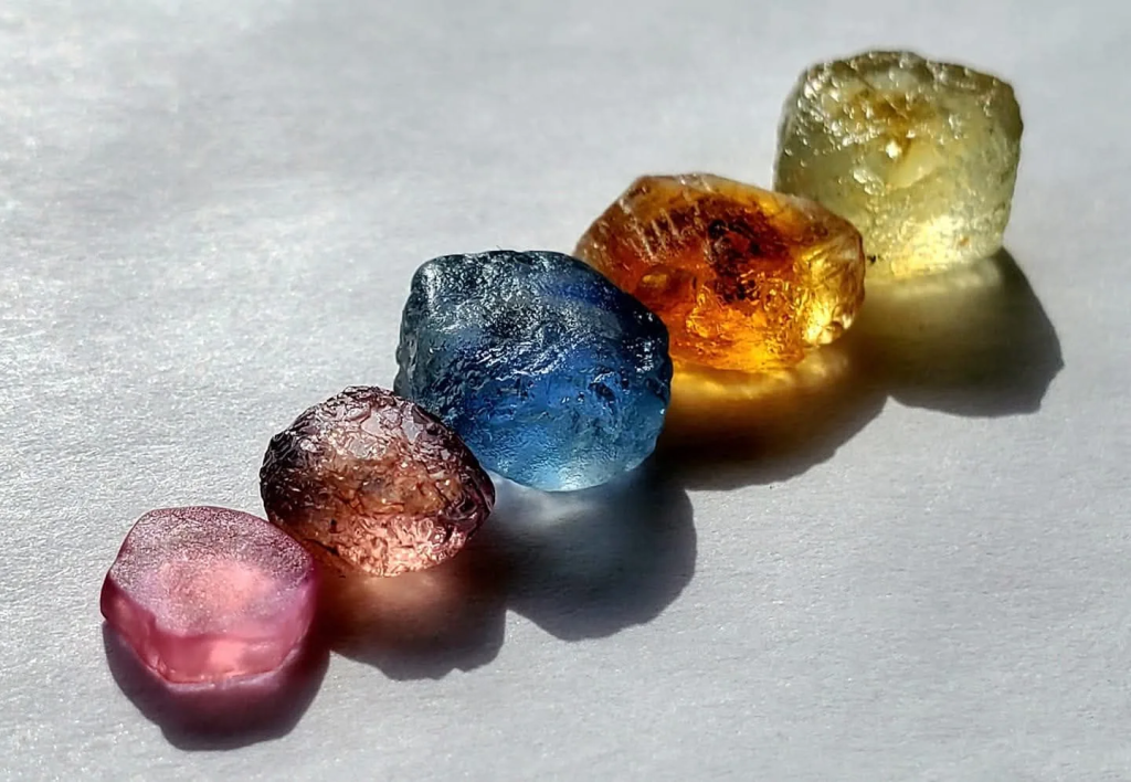
Located approximately 45 kilometers west of the regional hub of Emerald, The Willows gemfield occupies a distinct, revered position within the Central Queensland Gemfields hierarchy. Unlike the heavily commercialized open-cut zones of Sapphire and Rubyvale, The Willows is strictly preserved for low-impact hand mining and recreational fossicking. Corporate entities and heavy industrial earthmoving machinery are legally prohibited, creating an environment where the landscape remains largely undisturbed and the prospecting experience mirrors that of the early 20th century. The area is internationally celebrated among gemologists, lapidaries, and fossickers for yielding exceptional, high-clarity fancy-coloured sapphires. While deep royal blues dominate the wash in other parts of the Anakie district, The Willows is legendary for its vibrant golden-yellows, intense greens, pale pinks, and rare, multi-hued parti-coloured stones. Engaging in gemstone mining in Australia at this location provides an intimate connection to the earth.
| Mining Parameter | The Willows Specification | Engineering & Geological Context |
|---|---|---|
| Extraction Method | Hand Mining Exclusively | Zero mechanization; heavy industrial machinery is entirely illegal. |
| Wash Depth | Surface to 4 meters | Shallow leads, eluvial blankets, and ancient river terraces. |
| Target Material | Fancy-Coloured Corundum | Sourced from unique paleochannel networks with low iron signatures. |
- Unmechanized Extraction: Relies on manual specking, hand-shoveling, and portable riddles to process gravels.
- Trace Element Profile: Lower iron-to-titanium ratios yield canary yellows, greens, and pristine clarity.
- Community Framework: Sustained by seasonal camping reserves and off-grid prospector camaraderie.
3.1 Geological Provenance and Distinct Paleochannel Dynamics
The corundum deposits at The Willows share a fundamental volcanic origin with the broader Anakie field but display unique sedimentary transport and depositional characteristics that account for the distinct color profile and exceptional clarity of the gems.
3.1.1 Alkaline Basaltic Source and Vent Geochemistry
The original sapphire crystals were sourced from deep-seated alkali basaltic volcanism during the Tertiary period. Magmas ascending through the lithosphere brought the crystallized corundum to the surface. However, the specific volcanic vents and eruptive centers feeding the paleodrainage systems of The Willows appear to have possessed trace element signatures—specifically lower iron-to-titanium ratios and localized variations in oxygen fugacity—that favored the formation of yellow and green hues over deep, saturated blues. The lack of excessive iron prevents the crystallization paths from darkening into opaque or inky materials.
3.1.2 The Alluvial Shallow Lead Architecture
The wash at The Willows is predominantly found in shallow alluvial leads, ancient terraces, and localized eluvial sheets. Because the volcanic source rocks were weathered over millions of years, the durable corundum crystals were washed into relatively narrow, meandering paleochannels. These gravels are typically found at depths ranging from just a few centimeters beneath the topsoil to roughly three to four meters deep, making them perfectly accessible to hand-held tools such as picks, shovels, and hand-operated sieves without requiring deep shaft sinking or commercial open-cut operations.
3.2 Stratigraphy and the Philosophy of Hand Extraction
The geological matrix hosting the sapphires at The Willows consists of an indurated gravel conglomerate buried beneath a veneer of red-brown sandy soil and clay. The wash layer here is highly characteristic, comprising rounded quartzite and quartz pebbles indicative of a mature, high-energy fluvial transport environment, weathered volcanic detritus representing remnants of the degraded basaltic flows that originally carried the crystals to the surface, and massive silcreted sandstones known as billy boulders.
These billy boulders act as natural riffles in the ancient streambeds, catching heavy minerals including sapphires and zircons. To protect the integrity of the field and ensure sustainable access for generations of fossickers, the Queensland government has designated The Willows as an area strictly reserved for hand mining. The use of bulldozers, backhoes, front-end loaders, and mechanical wash plants is illegal. Prospectors must rely on visual specking—searching the surface of the ground or mullock heaps, particularly after rain when the sunlight catches the high luster of an exposed sapphire or zircon—and hand puddling and sieving. This manual extraction involves excavating the wash by hand, breaking up the clay matrix using water-filled tubs or portable puddlers, and classifying the gravels using a set of nested wire screens to isolate the heavy mineral concentrate.
3.3 Gemological Profile: The Realm of Golden-Yellows and High Clarity
The Willows holds an exalted status in the global gem trade due to the optical purity and vibrant, warm color palette of its sapphires. The absence of excessively high iron concentrations, combined with trace amounts of magnesium and color centers within the crystal lattice, prevents the stones from turning dark or inky blue.
- Golden Yellows: The Willows is world-famous for its bright, canary-yellow to deep golden-yellow sapphires. These stones exhibit exceptional brilliance and fire when properly faceted. The pinnacle of the field’s discoveries was the legendary “Golden Willow,” a magnificent 332-carat yellow sapphire unearthed by hand miners, which demonstrated the extraordinary size and clarity potential of this locality.
- Vibrant Greens and Parti-Colours: Fine, bright grassy-green, olive, and teal sapphires are regularly recovered, alongside parti-coloured stones that transition smoothly between yellow and green.
- Exceptional Optical Clarity: Corundum from The Willows frequently displays remarkable optical clarity, with minimal internal silk or inclusions. This makes the rough material highly sought after by master faceters aiming for clean, high-brilliance gemstones.
3.4 Associated Paragenesis and Heavy Mineral Suite
The heavy mineral concentrate retrieved alongside sapphires at The Willows provides clear evidence of the deposit’s magmatic and metamorphic history. Clastic, water-worn zircon crystals are ubiquitous in the sieves, ranging from transparent, colorless stones (often referred to locally as Matura diamonds) to rich honey-yellow and reddish-brown specimens.
Pleonaste (black spinel), occurring as sharp, lustrous octahedral crystals, is abundant in the wash and serves as an excellent visual indicator for fossickers. Additionally, dense, dark oxide minerals like ilmenite and magnetite form the heavy black sand base that remains in the sieve after washing the lighter quartz and clay fractions away, completing the classic paragenetic suite of the Anakie volcanic province.
3.5 Socio-Economic Framework: Campfire Culture and Sustainable Geotourism
The socio-economic structure of The Willows is entirely unique, defined by a tight-knit community of leaseholders, seasonal fossickers, and wandering prospectors who embrace an off-grid, self-reliant lifestyle.
3.5.1 The Fossicking Camping Reserve
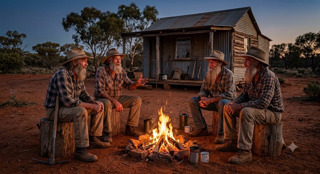
At the heart of the community is the designated fossicking camping reserve. The area attracts retirees, adventurous travelers, and artisan miners who set up semi-permanent camps, caravans, and motorhomes for the winter fossicking season. The social fabric of the field is deeply tied to the campfire culture, where daily finds are shared, geological theories are debated, and the pioneering spirit of independent prospecting is kept alive away from city distractions.
3.5.2 Geotourism and Sustainable Micro-Economy
The Willows operates as a sustainable micro-ecosystem supporting local caravan parks, small stores, and private wash-selling operations. Visitors can rent or buy basic hand tools, obtain the required fossicking licenses, and spend days walking the scrubland or working small, shallow pits. By preserving the field exclusively for non-mechanized extraction, the region ensures that the thrill of discovering a high-clarity fancy sapphire remains an accessible, experiential adventure for the public, cementing its reputation as Australia’s premier hand-mining sanctuary.
4.0 Tomahawk Creek: The Remote Frontier of Hand Mining and Heritage
Situated approximately 25 kilometers northwest of Rubyvale, Tomahawk Creek represents the most remote, rugged, and pristine designated fossicking area within the Central Queensland Gemfields network. Encompassing roughly 2,340 hectares of undulating, heavily timbered bushland, this specific locality holds a near-mythic status among prospectors, lapidaries, and mineral collectors. Unlike the highly commercialized and historically mechanized tracts of the main Sapphire and Rubyvale fields, Tomahawk Creek has never been subjected to corporate open-cut operations or heavy industrial washing plants. It is legally reserved exclusively for low-impact hand mining, surface specking, and small-scale tourist fossicking. The landscape is dotted with rare, heritage-listed miners’ huts and quiet, scattered campsites, offering an immersive step back in time to the early days of the Australian sapphire rushes. The region is highly acclaimed for producing exceptional fancy-coloured sapphires, unique crystal habits, and pristine, unbroken mineral specimens, including the famous and highly unusual “Tomahawk Tiger” dogtooth sapphire formation. Engaging in gemstone mining in Australia at this remote frontier provides an unparalleled experiential adventure.
| Mining Parameter | Tomahawk Creek Specification | Engineering & Geological Context |
|---|---|---|
| Extraction Mandate | Strictly Manual Labor Only | Zero mechanization; heavy earthmoving machinery is entirely prohibited. |
| Deposit Type | Proximal Alluvial & Eluvial | Sourced from short, steep paleochannels directly adjacent to weathered vents. |
| Morphology | Euhedral Crystals & Etched Habits | Minimal transport abrasion preserves pristine crystal faces and sharp structures. |
- Hand-Mining Exclusivity: Relies entirely on manual specking, shoveling, puddling, and hand-held riddles.
- Proximal Genesis: Short transport distances preserve delicate hexagonal bipyramidal habits and unique etch figures.
- Rustic Preservation: Retains pioneer infrastructure and off-grid heritage camping reserves.
4.1 Geological Genesis and Provenance Mechanisms
The sapphire deposits of Tomahawk Creek share the deep-seated, mantle-derived origins of the broader Anakie volcanic province, yet they display distinct localized depositional characteristics that set them apart from the lower alluvial plains.
4.1.1 Alkaline Basaltic Eruptions and Mantle Exhumation
During the Tertiary period, explosive volcanic activity associated with the Hoy Basalt Province tore through the Earth’s crust. These explosive events brought deep-seated xenoliths and crystallized corundum up to the surface. The volcanic vents responsible for the Tomahawk Creek gravels were situated along the higher, undulating terrain surrounding the creek’s headwaters, acting as the primary point of exhumation for these durable, high-pressure minerals.
4.1.2 Eluvial and Proximal Alluvial Concentration
The critical geological distinction of Tomahawk Creek lies in its status as a proximal deposit. Rather than being transported hundreds of kilometers down massive, high-energy river systems, the sapphires here were deposited in relatively short, steep palaeodrainage channels and eluvial blankets directly adjacent to the weathered volcanic pipes. This short transport distance prevented the crystals from undergoing severe abrasion, resulting in a higher frequency of unbroken, euhedral crystal faces, sharp rhombohedral forms, and delicate hexagonal bipyramidal habits.
4.2 Stratigraphy and Non-Mechanical Extraction Methodologies
The sapphire-bearing wash at Tomahawk Creek is found in a variety of shallow terrestrial settings, ranging from hillslope eluvial deposits to thin, meandering gravel sheets in modern and ancient creek beds. The wash horizon typically lies beneath a thin veneer of topsoil and barren sandy clay, rarely exceeding two to three meters in depth, making it an accessible target for artisanal prospectors.
4.2.1 Composition of the Wash Matrix
The conglomerate comprises sub-angular quartz pebbles indicative of moderate fluvial transport, ferruginous sandstone and ironstone nodules locally known as billy boulders, unaltered basaltic detritus representing remnants of the original volcanic host rocks, and dense clay binders. Though less indurated than the deep leads of Rubyvale, the gravels are bound by a sticky, iron-rich clay that requires thorough puddling to break down.
4.2.2 Strict Hand-Mining Mandate
Because the use of bulldozers, backhoes, and mechanical wash plants is strictly prohibited by mining regulators, prospectors must rely entirely on manual labor. This preserves the environmental integrity of the 2,340-hectare reserve and ensures that the ground is not systematically stripped. The extraction process is methodical, beginning with surface specking—wandering the dry gullies and surface exposures, particularly after heavy summer downpours wash away the top layer of dust, visually scanning for the sub-adamantine luster of sapphires or the bright glint of clear zircons. It progresses to shoveling and puddling, which involves sinking small, temporary hand pits to access the wash layer, shoveling the gravel into portable tubs of water, and washing the material to dissolve the clay. Finally, riddling and classification require manually shaking nested wire screens to separate the gravels by size, allowing the fossicker to pick through the dense heavy mineral concentrate directly in the field.
4.3 Gemological Profile of Tomahawk Creek Corundum
Tomahawk Creek corundum is prized by collectors and bespoke jewelers for its exceptional optical clarity, unusual trace-element zoning, and rare crystal morphologies that survive the short sedimentary journey.
4.3.1 Crystal Habit and Etched Forms
Due to the proximal nature of the deposits, sapphires from Tomahawk Creek frequently exhibit pristine crystal faces. Many stones show complex dissolution features, trigonal etch pits, and smooth, rounded faces resulting from resorption by the ascending magma or subsequent chemical weathering in the soil profile.
4.3.2 The “Tomahawk Tiger” and Unique Parti-Colour Schemes
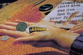 The locality is globally famous for unusual color combinations and rare structural phenomena. It occasionally yields elongated, pointed sapphire crystals resembling dogtooth spar (calcite) or sharp bipyramids, which are highly sought after by mineral specimen collectors. Furthermore, the Tomahawk Tiger is a descriptive term given to unusual, strongly color-zoned or banded sapphires that display sharp, alternating lines of golden-yellow, bronze, and deep, smoky green. These stones, when cut, exhibit a mesmerizing, chatoyant or striped effect reminiscent of a tiger’s eye, making them highly prized by bespoke jewelry designers. While deep royal blues are recovered, the field is dominated by fancy-coloured material, including vibrant canary yellows, olive greens, pale lilacs, and rare, pinkish-orange corundum. The clarity of the rough is generally high, allowing for clean, brilliant faceted gemstones.
4.4 Associated Paragenesis and Indicator Mineralogy
The heavy mineral suite found alongside sapphires in the Tomahawk Creek sieves provides clear evidence of the deposit’s rich, deep-mantle and crustal provenance. Identifying these accessory species confirms that prospectors are working within the targeted gravel horizon.
- Zircon: Abundant, highly lustrous, and water-worn zircon crystals are found in every sieve. They range from colorless, diamond-like stones to deep amber and reddish-brown varieties, serving as reliable indicators of ancient heavy mineral concentration.
- Pleonaste (Black Spinel): Sharp, octahedral crystals of black spinel are incredibly common, serving as a reliable visual indicator to prospectors that they are working within the correct gravel horizon.
- Ilmenite and Magnetite: These dense, opaque black oxides form the heavy black sand concentrate at the bottom of the riddle, which must be carefully panned out to reveal the colored gems.
- Exotic Associates: On rare occasions, the wash yields fragments of translucent green tourmaline, almandine garnet, and even rare, microscopic industrial diamonds, highlighting the exotic, deep-crustal suite of the Anakie volcanic field.
4.5 Socio-Economic Fabric and Heritage Preservation
The socio-economic framework of Tomahawk Creek is defined by off-grid self-reliance, rustic heritage, and a deep commitment to environmental preservation that contrasts sharply with industrial extraction.
5.0 Anakie & Glenalva: The Historical Gateway and Shallow Alluvial Flats
The Anakie and Glenalva localities represent the geographic, historical, and infrastructural gateway to the entire Central Queensland Gemfields network. Situated directly along the Capricorn Highway, the township of Anakie serves as the primary transit hub where prospectors, tourists, and commercial buyers historically disembarked by rail to access the rugged interior mining camps. While the immediate Anakie townsite sits on non-productive bedrock, it is immediately flanked by highly accessible, historically significant shallow wash areas, most notably the Glenalva fossicking reserve. Glenalva is internationally recognized for yielding excellent blue and fancy-colored sapphires from incredibly shallow, easily workable gravel layers, making it an ideal proving ground for novice fossickers and a reliable source of gem material for artisanal miners engaging in gemstone mining in Australia.
| Mining Parameter | Anakie-Glenalva Specification | Engineering & Geological Context |
|---|---|---|
| Deposit Profile | Surficial Eluvial & Alluvial Sheets | Wide, sheet-like gravel deposits requiring minimal overburden removal. |
| Wash Depth | 0.1m to 1.5m | Highly accessible to non-mechanized hand tools and shallow scraping. |
| Hydraulic Gradient | Low-Energy Confluence | Formed broad valley systems spreading out from highland volcanic centers. |
- Geographic Positioning: Acts as the vital transit and supply corridor for the broader inland mining district.
- Sedimentary Dynamics: Lower hydraulic gradients facilitated the widespread distribution of extensive sheet gravel blankets.
- Accessibility: Shallow, unconsolidated overburdens make this sector perfect for educational tourism and recreational fossicking.
5.1 Geographic Positioning and Paleodrainage Context
The geological positioning of the Anakie and Glenalva sectors places them at the lower, broader reaches of the ancient Tertiary drainage networks that flowed eastward from the highland volcanic centers. During the Eocene and Miocene epochs, the weathering basaltic plateaus shed immense volumes of weathered debris, including exhumed corundum crystals. The streams feeding the Anakie and Glenalva areas coalesced into broader, lower-energy valley systems compared to the steep, confined gullies of the upper tablelands.
This reduction in hydraulic gradient allowed for the widespread deposition of extensive, sheet-like gravel deposits rather than narrow, deeply incised deep leads. The landscape around Glenalva is characterized by gently undulating hills, wide alluvial flats, and shallow, dry creek beds. The sapphire-bearing wash in this locality is frequently found as thin eluvial blankets—gravels left behind as the surrounding bedrock and softer shales weathered away—or as shallow alluvial sheets sitting just beneath a veneer of modern topsoil and aeolian sands.
5.2 Stratigraphy of the Glenalva Wash
The stratigraphic profile of the Glenalva fossicking area is highly favorable for hand-mining and recreational prospecting due to its proximity to the surface and the relatively unconsolidated nature of its overburden.
5.2.1 The Overburden Profile
In most sections of the Glenalva field, the barren overburden consists of a thin, loose sandy loam topsoil that is easily scraped away with hand tools, followed by a pale, slightly compacted sandy clay subsoil layer that rarely exceeds one meter in thickness, shielding the ancient gravels below.
5.2.2 Composition of the Sapphire-Bearing Conglomerate
Beneath the subsoil lies the primary wash layer. The conglomerate here is less indurated than the deep leads of Rubyvale, though it still features a sticky clay binder that requires washing. The wash consists of sub-angular to well-rounded quartz pebbles indicative of mature, sustained fluvial transport, weathered basaltic detritus and feldspar fragments highlighting the volcanic provenance of the sediments, and silcrete and ironstone nodules known as billy boulders. These hard, durable cobbles acted as physical traps for dense heavy minerals during the Tertiary period. The wash layer typically ranges from 10 centimeters to half a meter thick, resting unconformably on deeply weathered Palaeozoic sedimentary or metamorphic basement rocks.
5.3 Gemological Profile of Anakie-Glenalva Corundum
Sapphires recovered from the Anakie and Glenalva localities display a broad spectrum of gemological properties, reflecting the diverse volcanic vents that fed the paleoriver systems across the Hoy Basalt Province.
5.3.1 Color Palette and Trace Element Signatures
The chemical environment of crystallization, governed by the Hoy Basalt Province, introduces significant amounts of iron and titanium into the corundum crystal lattice, dictating its fundamental appearance.
- Saturated Royal Blues: The locality is historically famous for producing classic, highly saturated royal blue sapphires. The high iron content suppresses internal fluorescence and deepens the blue hue, yielding a rich, velvety appearance.
- Parti-Colouring and Bicolor Stones: Fluctuations in trace element availability during crystal growth produced strongly zoned corundum. Parti-coloured sapphires that transition smoothly between distinct sectors of green, yellow, and blue are frequently recovered in the Glenalva gravels.
- Fancy Colours and Clarity: While blues dominate, the field also yields bright green stones, pale yellow corundum, and occasional grayish-violet specimens. The overall clarity of Glenalva sapphires is highly variable, with some crystals displaying clean, gemmy interiors while others are heavily included with microscopic rutile silk or exsolution planes.
5.4 Associated Paragenesis and Heavy Mineral Suite
The high-energy fluvial environments that concentrated the dense sapphire crystals also trapped a robust suite of durable indicator minerals, which prospectors use to confirm the presence of the true wash horizon.
6.0 Middle Ridge: The Consolidated Gravels and Dedicated Fossicking Zone
Located centrally between the designated fossicking lands of The Divide and Rubyvale, the Middle Ridge locality represents a highly specific, government-regulated fossicking area established to preserve artisanal prospecting opportunities within the Central Queensland Gemfields. Encompassing a compact but intensely mineralized zone, Middle Ridge is well known for offering prospectors the choice of recovering sapphires and associated gemstones either near the surface in eluvial gravels or at slightly greater depths within consolidated, ancient paleochannel wash. The geological framework of Middle Ridge requires a methodical approach to extraction. The wash layers are often indurated and bound by dense, weathered volcanic clays, demanding patience, physical effort, and proper processing techniques to fully liberate the hidden corundum reserves that make commercial Australian gemstones mining districts globally renowned.
| Mining Parameter | Middle Ridge Specification | Engineering & Geological Context |
|---|---|---|
| Stratigraphic Complexity | Dual Wash Horizons | Surface eluvial rubble overlaying a highly compacted bottom conglomerate. |
| Wash Depth | 0.4m to 2m+ | Requires manual potholes to penetrate barren intercalated clay layers. |
| Processing Requirement | Soaking and Puddling | Tenacious weathered volcanic clay matrix demands extensive soaking. |
- Dual Stratigraphy: Prospectors encounter a surficial eluvial layer and a deeper, highly indurated paleochannel wash.
- Manual Potholing: Extraction relies on targeted hand-sinking of small pits using heavy mattocks and picks.
- Prerequisite Soaking: Tenacious volcanic clays lock the corundum, necessitating long submersions before classification.
6.1 Geological Setting and Paleochannel Architecture
The depositional environment at Middle Ridge reflects a complex history of localized basaltic weathering, fluvial transport, and subsequent landscape modification. The region sits securely within the broader influence of the Hoy Basalt Province, which provided the primary alkaline volcanic activity responsible for exhuming deep-mantle corundum crystals during the Tertiary period. The localized drainage networks that fed the Middle Ridge basin were relatively short, resulting in coarse, angular to sub-rounded gravel suites trapped against Palaeozoic granitic and metamorphic basement rocks.
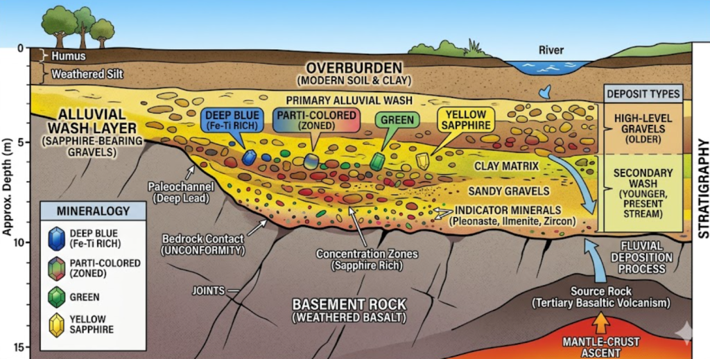
The stratigraphy of Middle Ridge is notable for exhibiting distinct, multiple wash horizons within relatively shallow depths. According to geological surveys of the area, prospecting pits frequently reveal a secondary surface wash—a thin, rubbly soil and pebble layer found within the top 400 millimeters of the surface. While this layer can yield small, liberated gems, it is generally secondary and less concentrated. Below this lies a barren intercalated layer, consisting of a dense, brown or reddish-brown clay stratum separating the surface gravels from the primary deep wash. Beneath this barren clay sits the indurated bottom wash—a highly compacted, boulder-strewn conglomerate layer found at depths of roughly one meter to two meters (and occasionally extending deeper in isolated leads, such as those near Shotgun Hill and Policemans Flat). This bottom wash contains a heavy matrix of sticky clay, weathered basaltic detritus, and massive silcrete billy boulders acting as natural riffles.
[Image of geological cross-section of paleochannel]6.2 Extraction Methodologies for Consolidated Gravels
Because Middle Ridge is a dedicated fossicking area managed under recreational and small-scale artisanal mining legislation, heavy earthmoving machinery or industrial open-cut stripping is prohibited. Prospectors utilize manual extraction techniques suited to breaking through indurated clay and gravel conglomerates.
6.2.1 Potholing and Manual Sinking
Miners and recreational fossickers sink small, targeted hand pits (often referred to as potholing) to reach the consolidated bottom wash. Because the clay binder is highly tenacious and packed with large billy boulders, excavation requires heavy hand tools, including mattocks, short-handled picks, and heavy-duty shovels.
6.2.2 Soaking and Puddling Requirements
Shoveling the indurated wash directly into a dry screen will yield very little, as the valuable gems are firmly embedded and the wash must be soaked and agitated to liberate them for collection.
7.0 Conclusion: The Enduring Legacy and Future of the Central Queensland Gemfields
The Central Queensland Gemfields represent a fascinating intersection of ancient geological cataclysms and resilient human enterprise. Spanning the deeply weathered expanses of the Anakie Mining District, locations such as Sapphire, Rubyvale, The Willows, Tomahawk Creek, Anakie-Glenalva, and Middle Ridge each contribute a distinct chapter to Australia’s rich tapestry of gemstone mining. From the deep underground shafts of the pioneer days to the strictly preserved hand-mining sanctuaries of the modern era, these fields have continuously adapted to the shifting economic tides of the global jewelry trade.
7.1 The Synthesis of Heritage and Modern Artisanal Enterprise
The transition of the gemfields from unregulated, rough-and-frontier rushes to a highly structured ecosystem balancing mechanized extraction and experiential geotourism demonstrates remarkable sustainability. While industrial open-cut operations utilize advanced earthmoving machinery to process vast tonnages of indurated conglomerate wash, the preservation of non-mechanized zones like The Willows and Tomahawk Creek ensures that the fundamental thrill of prospecting remains accessible to independent fossickers, artisan miners, and educational travelers. This coexistence of scales safeguards the pioneer heritage inscribed in the local ironstone billy boulders, rough-hewn timber, and heritage-listed miners’ huts.
Furthermore, the paragenetic suite of durable indicator minerals—ranging from clastic zircons and lustrous black spinel to heavy black sands of ilmenite and magnetite—continues to serve as an empirical foundation for prospectors tracing ancient paleochannel networks. By demanding a meticulous, data-first approach to potholing, soaking, puddling, and riddling, the region weeds out speculative decay, rewarding patience, physical effort, and geological understanding.
7.2 The Resurgence of Coloured Gemstones in the Modern Market
On a global gemological scale, the corundum reserves of the Anakie district occupy an essential position. The unique geochemical environments governed by Tertiary alkali-volcanic activity impart high concentrations of iron and titanium into the crystal lattice, yielding velvety royal blues, vibrant greens, and unique parti-coloured schemes. The historical pivot during the post-war mechanization boom—where previously discarded opaque or dark “ink-blue” rough was embraced by international merchants for thermal enhancement—proves the adaptability of the local industry.
Looking toward contemporary and future markets, particularly with coloured gemstones emerging as a premier focus, the exceptional clarity and fancy-coloured material sourced from shallow alluvial leads positions the Central Queensland fields at the forefront of bespoke, ethical jewelry supply chains. Whether for master faceters seeking flawless canary yellows from The Willows or bespoke designers hunting for the banded, chatoyant beauty of a Tomahawk Tiger, the output of these fields remains unrivaled.
Ultimately, the region remains far more than a historical relic of Australia’s resource rushes. It stands as a vibrant, enduring landscape of discovery, geo-education, and artisanal resilience, inviting a new generation of prospectors to sink their shovels into the ancient gravels and uncover the hidden treasures of the outback.